Product DescriptionTopographic Surveying Instrument FOIF A90 with
Hemisphere BoardFunction Feature 1. Compact design, more
productive2. Professional GNSS satellites tracked simultaneously(
GPS, Glonass, Galileo, Beidou)3. Automatic data collection during
centering4. It could get the right point data by automatic correct
system with IMU when the pole is tilted in 60 degrees.5. Applies
WIFI connection to realize WebUI control designed to modify
settings and monitor the receiver status6. Bundled Android field
software brings a big change in user experience and
accessibility Function Feature1. Performance values assume
minimum of five satellites, following the procedures recommended in
the product manual,High-multipath areas, high PDOP values and
periods of severe atmospheric conditions may degrade
performance.*2. Long baselines, long occupations, precise ephemeris
used.FOIF Geomatics CADMain functions include:DWG file format,
compatible with AutoCAD Integrated transformation and grid system
computationsFull 3D least squares adjustment, blunder detection,
graphical elipse displayDTM contouring/Modeling volumes/3D
renderingSite Design: Ponds, ditches, stockpiles and siopesRoad
Design: horizontal and vertical alignments, cross sectional
templatesCompletely customizable user interface* Toolbars-can be
arranged with "drag and drop" functionality* Menus- can be
re-organized with our graphical menu editor* Screen- items can be
turned off for more graphics area* Layout- of command window- top
or bottomReporting, exporting and printingProduct
Parameters ItemsSpecificationGNSS EngineGNSS boardTrimble
BD990 boardChannel336SatellitesGPS: L1 C/A, L2E, L2C, L5GLONASS: L1
C/A, L2 C/A, L3 CDMA14BeiDou: B1, B2, B313Galileo: E1, E5A, E5B,
E5AltBOC, E614IRNSS: L5 SBAS: L1C/A, L5QZSS: L1 C/A, L1 SAIF,
L1C, L2C, L5, LEXMSS L-Band: OmniSTAR, Trimble RTXTilt survey: The
forth generation Tilt Technology, IMU functionReal-Time
Accuracy(rms)SBASHorizon: 60cm(1.97ft); Vertical:
120cm(3.94ft)Real-Time DGPS positionHorizon: 40cm(1.31ft);
Vertical: 80cm(2.62ft)Real-Time Kinematic PositionHorizontal:
1cm(0.03ft)+1.0ppm; Vertical: 2.5cm(0.08ft)+1.0ppmReal-Time
PerformanceStop and Go solutionInstant-RTK
Intialization Typically
Quality Topographic Surveying Instrument Foif A90 with Hemisphere Board products, provide good price Topographic Surveying Instrument Foif A90 with Hemisphere Board from .
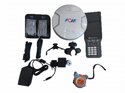
Larger photo of Topographic Surveying Instrument Foif A90 with Hemisphere Board
Related products about Topographic Surveying Instrument Foif A90 with Hemisphere Board
-
 Waste Tyre Plastic Recycling Machinery Machine Tire Crusher Production Line Rubber Crumb Grinding Machine Equipment Tire Shredder
-
 Stretch Plastic Blowing Pet Bottle Making Blow Molding Machine Bottles Stretch Automatic Pet Bottle Blowing Machine
-
 Waste Plastic Pet Bottle, Water Bottle Flake, PP/HDPE/LDPE PE Film Jumbo Woven Bags Plastic Crusher Machine, Plastic Crushing Washing Recycling Machine
-
 Type 2 Wall-Mounted Electric Car Charging Station 7kw /11 Kwelectric Vehicle Charging Station Home Wallbox AC EV Charger Single Phase or 3three Phase
-
 G-View G12W Wholesale Auto Car LED Headlight Bulb High Power H13 H11 9005 H7 H4 Car LED Headlights LED Car Lights
-
 New Design Porcelain Round Plates Dinner Set for Wedding and Banquet
-
 China 2023 New Design Super Soft 100% Polyester Microfiber Knitted Oversized Decoration Hoodie Blanket
-
 Handmade Art Creative Materials Thickened White Paper Cup DIY Disposable Handmade Colored Paper Cup


