Product DescriptionDouble Star Doctor etrexC-- an expert in mu
measurementExperts in field acquisition and area measurement: High
sensitivity new generation double star (GPS+GLONASS) fast
positioning capability, more than 48 satellites for your service,
multiple coordinate systems and format conversion, professional
area measurement function, light weight and power saving, solid
three defense design.1.Dual satellite reception: GPS and GLONASS
can be received simultaneously, making positioning faster and more
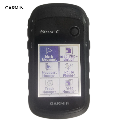
accurate. 2.Area surveying and mapping: provide multiple types of
area measurement, accurate area and length measurement and
real-time display, and have the function of midway pause and switch
on/off for continuous measurement. 3.Track measurement: measure the
area enclosed by the user's walking track with the equipment(the
starting and ending points are connected in a straight line).
4.Route measurement: the user creates a route to calculate the area
of the area enclosed by the route. 5.Equal width measurement:
calculate the area (width multiplied by track length) according to
the fixed width entered by the user and the walking track of the
handheld device. 6.Coordinate system: Beijing 54, Xi'an 80 and
CGCS2000 coordinate systems and display formats are available.
7.Track recording: multiple track recording modes, such as time
interval, distance interval and automatic, meet various
requirements under different conditions. 8.Low power consumption:
two No.5 batteries can be used for more than 25 hours (50% less
power than traditional products). Specifications Hardware and
performance product size(CM) 5.4×10.3×3.3 Screen SizeCM(inch)
3.5×4.4(2.4) Screen resolution 128×160 Screen color Semi
transmissive monochrome display Touch Screen NO Memory NO Support
memory card NO Weight(with battery) 141.7g Working Time 25h
Waterproof index IPX7 Floatable NO Conmutador de coordenadas NO
Positioning accuracy (optimal state) Within 3M Satellite system
GPS+GLONASS Interface USB Data record Number of waypoints 1000
Route (piece× Point) 50×250 Track record (point) 9999 Save track
(piece× Point) 100x10000 MAP Pre loaded detailed map NO Pre loaded
background map Town point map Ability to add maps NO Support
navigation map NO Support for tide tables NO Function Electronic
compass NO Barometric altimeter NO Track measurement area YES Route
survey area YES Position averaging YES beijing54/xi'an80/CGCS2000
YES Buzzer sound reminder NO Support custom interest points NO
wireless data transmission NO Photographic function NO Picture
browser NO Photo navigation NO Custom attribute collection NO
External antenna interface NO Geocaching geographic
treasures NO Standard Package Garmin GPS, wrist strap and User
Manual Package Company
ProfileShanghai Apekstool was founded and based in Shanghai,
specializing in the manufacturing and sales of Surveying equipment.
We are dedicated to being a professional provider for survey
equipment. Our goal is to provide the best products and excellent
service to our customers all over the world.We have been involved
in the geographic mapping industry for 10 years. We supply all
products with reasonable prices and real-time support upon our own
professional experience and high-quality supply chain. Like gnss
rtk, total station, theodolite, auto level, rotary laser level,
laser level and surveying accessories. We have sold to more than
156 countries and build our stable market.We are proud to guarantee
that, with our strong technical background and communication
capability, our sales/support engineers are able to answer your
most complicated technical questions over the phone in English.
That would save so much time for communication. Our business is
growing and we invite you to be part of the
success. /* January 22, 2024 19:08:37
*/!function(){function s(e,r){var
a,o={};try{e&&e.split(",").forEach(function(e,t){e&&(a=e.match(/(.*?):(.*)$/))&&1
Quality Hot Sale GPS Handheld Garmin Etrex C Etrex 10 products, provide good price Hot Sale GPS Handheld Garmin Etrex C Etrex 10 from .
Larger photo of Hot Sale GPS Handheld Garmin Etrex C Etrex 10
Related products about Hot Sale GPS Handheld Garmin Etrex C Etrex 10
-
 Waste Tyre Plastic Recycling Machinery Machine Tire Crusher Production Line Rubber Crumb Grinding Machine Equipment Tire Shredder
-
 Stretch Plastic Blowing Pet Bottle Making Blow Molding Machine Bottles Stretch Automatic Pet Bottle Blowing Machine
-
 Waste Plastic Pet Bottle, Water Bottle Flake, PP/HDPE/LDPE PE Film Jumbo Woven Bags Plastic Crusher Machine, Plastic Crushing Washing Recycling Machine
-
 Type 2 Wall-Mounted Electric Car Charging Station 7kw /11 Kwelectric Vehicle Charging Station Home Wallbox AC EV Charger Single Phase or 3three Phase
-
 G-View G12W Wholesale Auto Car LED Headlight Bulb High Power H13 H11 9005 H7 H4 Car LED Headlights LED Car Lights
-
 New Design Porcelain Round Plates Dinner Set for Wedding and Banquet
-
 China 2023 New Design Super Soft 100% Polyester Microfiber Knitted Oversized Decoration Hoodie Blanket
-
 Handmade Art Creative Materials Thickened White Paper Cup DIY Disposable Handmade Colored Paper Cup


