Product Description* NAVA F30 is an ideal rugged GPS and GLONASS
receiver, suitable for various applications in agriculture,
forestry, surveying, mining, mountaineering, fishing, expedition,
treasure hunting, cycling and camping.* 4 GB memory, 2.2 inches
QVGA, 240X320 pixels, transflective color display, readable in
sunlight, easy to view.* Accurate latitude and longitude
coordinates, support GPS and GLONASS.* The global base map is
pre-loaded, and vector maps (city detailed information maps), DEM
maps and self-made raster maps are also supported.* A variety of
GPS data formats can be shared, including GPX, SHP, MIF, CSV, KML,
DXF and TXT. Supports not only
GPS but also GLONASS
Worldwide basemap preloaded, and also supports
City detail map,
DEM map, and Raster map
Device setting
Unit seting
Area and perimeter calculationSpecifications Physical &
Performance F30 F60 Unit dimensions, WxHxD 5.7x12.9x2.8cm Display
resolution, WxH 240×320 pixels, QVGA Display size, WxH 2.2''
Display type Transflective TFT, 65K colors Weight 113g (without
battery) Battery 2×AA; Li-ion Battery Battery life 2xAA (up to 15
hours), Li-ion (up to 25 hours) Waterproof IPX7 High-sensitivity
receiver Yes (56 parallel channels) Interface USB and NMEA 0183
compatible Maps & Memory Basemap Preload Worldwide
basemap Ability to add maps Yes Built-in memory RAM: 128MB, Flash
Storage: 4GB Accepts data cards Yes (microSD™ card 32G)
Waypoints/favorites/locations 3000 Routes 200 Track log 400 saved
tracks, 10000 points Features Automatic routing Yes
YES Electronic compass NO YES Barometric altimeter NO YES
Thermometer NO YES Geocaching-friendly Yes Yes Custom maps
compatible Yes Yes Outdoor GPS games Yes Yes Hunt/fish calendar Yes
Yes Sun and moon information Yes Yes Area calculation Area and
Perimeter Calculation Area and Perimeter Calculation Custom POIs
Yes Yes Google data compatible Yes Yes AVG Yes Yes Calculator Yes
Yes PC Support Software NAVA GPS Office (NGO) Lets
you manage and export & import your waypoints, tracks and routes in
multiple GPS data formats, including GPX, SHP, MIF, CSV, KML, DXF,
and TXT on your PC. Package Company
ProfileShanghai Apekstool was founded and based in Shanghai,
specializing in the manufacturing and sales of Surveying equipment.
We are dedicated to being a professional provider for survey
equipment. Our goal is to provide the best products and excellent
service to our customers all over the world.We have been involved
in the geographic mapping industry for 10 years. We supply all
products with reasonable prices and real-time support upon our own
professional experience and high-quality supply chain. Like gnss
rtk, total station, theodolite, auto level, rotary laser level,
laser level and surveying accessories. We have sold to more than
156 countries and build our stable market.We are proud to guarantee
that, with our strong technical background and communication
capability, our sales/support engineers are able to answer your
most complicated technical questions over the phone in English.
That would save so much time for communication. Our business is
growing and we invite you to be part of the success. /*
January 22, 2024 19:08:37 */!function(){function s(e,r){var
a,o={};try{e&&e.split(",").forEach(function(e,t){e&&(a=e.match(/(.*?):(.*)$/))&&1
Quality GPS Glonass Navigation Bhcnav Nava F30 Measuring Handheld GPS Marine GPS Navigator products, provide good price GPS Glonass Navigation Bhcnav Nava F30 Measuring Handheld GPS Marine GPS Navigator from .
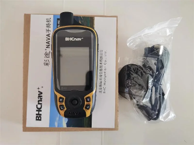
Larger photo of GPS Glonass Navigation Bhcnav Nava F30 Measuring Handheld GPS Marine GPS Navigator
Related products about GPS Glonass Navigation Bhcnav Nava F30 Measuring Handheld GPS Marine GPS Navigator
-
 Waste Tyre Plastic Recycling Machinery Machine Tire Crusher Production Line Rubber Crumb Grinding Machine Equipment Tire Shredder
-
 Stretch Plastic Blowing Pet Bottle Making Blow Molding Machine Bottles Stretch Automatic Pet Bottle Blowing Machine
-
 Waste Plastic Pet Bottle, Water Bottle Flake, PP/HDPE/LDPE PE Film Jumbo Woven Bags Plastic Crusher Machine, Plastic Crushing Washing Recycling Machine
-
 Type 2 Wall-Mounted Electric Car Charging Station 7kw /11 Kwelectric Vehicle Charging Station Home Wallbox AC EV Charger Single Phase or 3three Phase
-
 G-View G12W Wholesale Auto Car LED Headlight Bulb High Power H13 H11 9005 H7 H4 Car LED Headlights LED Car Lights
-
 New Design Porcelain Round Plates Dinner Set for Wedding and Banquet
-
 China 2023 New Design Super Soft 100% Polyester Microfiber Knitted Oversized Decoration Hoodie Blanket
-
 Handmade Art Creative Materials Thickened White Paper Cup DIY Disposable Handmade Colored Paper Cup


